100% Online
Complete your Penn State course work at your own pace and 100% online.
Application deadline
Credits and costs
10-Week Terms
Finish your program faster with accelerated 10-week terms.
Gain Geospatial Skills in Remote Sensing and Earth Observation
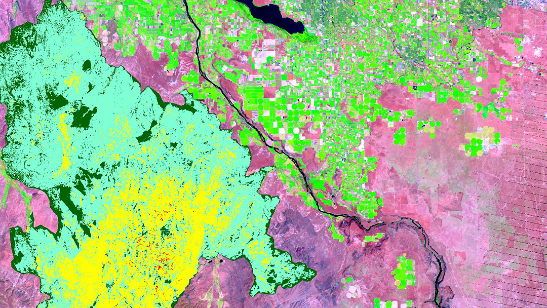
Work with remotely sensed imagery and terrain models.
Use computational methods to automate the spatial analysis of earth observation data and integrate those skills into a GIS workflow.
Collect data and analyze images to provide spatial insights for improved decision-making in business, crisis management, natural resources and energy, urban planning, and public safety.
Prepare to sit for the GISP, ASPRS, and/or USGIF certification exams.
Online Remote Sensing and Earth Observation Courses
Online Remote Sensing and Earth Observation Courses
This 12-credit certificate explores the science of acquiring information about the Earth from images and sensor networks.
As a geospatial professional who possesses a working knowledge of fundamental principles in the GIS discipline, you can learn to:
- use remote sensing technologies to collect data
- analyze images to provide spatial insights for improved decision-making in domains like business, crisis management, ecology, and the energy sector
- develop a foundation in remote sensing, terrain mapping, and image analysis
- apply the theory, methodologies, and techniques for the professional application of remote sensing in geographic information systems and analysis
As a leader in online geospatial education, we constantly refine our curriculum to incorporate emerging trends to ensure that you gain skills using today's most widely used technologies and analytical methods.
Required Courses (9 credits)
To earn your remote sensing certificate, it is recommended that you take courses in the following order:
- 3credits
Using imagery and terrain data in typical application scenarios faced by the geospatial professional.
- Prerequisite
GEOG 482 or equivalent professional experience
- Note
For individuals with professional experience in GIS, these prerequisites may be waived as part of the application review process.
- 3credits
Using airborne topographic lidar to create elevation models for GIS applications.
- Prerequisite
GEOG 362 or GEOG 480; GEOG 160 or GEOG 482; or equivalent professional experience
- Note
For individuals with professional experience in GIS, these prerequisites may be waived as part of the application review process.
- 3credits
Understanding remote sensing systems' operation, data products, and processing techniques to address typical problem scenarios faced by the GEOINT professional.
- Prerequisite
GEOG 480
Electives (select 3 credits)
Select one course from the following list or from other electives (at the discretion of the program director).
- 3credits
Highlights emerging theoretical and methodological trends in high-performance remote sensing for geospatial analysis through discussion and laboratory experiences.
- Prerequisite
GEOG 480 and GEOG 883
- 3credits
Introduces theory and methods for operating an unmanned aerial system for geospatial data acquisition and analysis.
- Prerequisite
GEOG 480
Course Availability
If you're ready to see when your courses will be offered, visit our public LionPATH course search (opens in new window) to start planning ahead.
Start or Advance Your Career
Start or Advance Your Career
You can use the knowledge gained from this program and the support of Penn State career resources to pursue careers in a variety of fields, depending on your goals.
Career Services to Set You Up for Success

From the day you're accepted as a student, you can access resources and tools provided by Penn State World Campus Career Services to further your career. These resources are beneficial whether you're searching for a job or advancing in an established career.
- Opportunities to connect with employers
- Career counselor/coach support
- Occupation and salary information
- Internships
- Graduate school resources
Ready to Learn More?
Get the resources you need to make informed decisions about your education. Request information on this program and other programs of interest by completing this form.
Ready to take the next step toward your Penn State graduate certificate?
Costs and Financial Aid
Costs and Financial Aid
Learn about this program's tuition, fees, scholarship opportunities, grants, payment options, and military benefits.
Costs and Financial Aid
Graduate Tuition
Graduate tuition is calculated based on the number of credits for which you register. Tuition is due shortly after each semester begins and rates are assessed every semester of enrollment.
2024–25 Academic Year Rates
| How many credits do you plan to take per semester? | Cost |
|---|---|
| 11 or fewer | $1,027 per credit |
| 12 or more | $12,325 per semester |
2025–26 Academic Year Rates
| How many credits do you plan to take per semester? | Cost |
|---|---|
| 11 or fewer | $1,037 per credit |
| 12 or more | $12,448 per semester |
Paying for Your Certificate
Students pursuing this certificate may be eligible for federal student aid. Find more information from the online geospatial education program office.
Additionally, Penn State offers many ways to pay for your education, including an installment plan and third-party payments. Penn State World Campus also offers an Employer Reimbursement and Tuition Deferment Plan. Learn more about the options for paying for your education.
Students pursuing a degree and meeting all other eligibility requirements may qualify for financial aid.
Military Benefits
Military service members, veterans, and their spouses or dependents should explore these potential military education benefits and financial aid opportunities, as well.
Additional Cost of Attendance Details
To view the detailed list of cost of attendance elements:
- visit the Tuition Information site
- click the plus sign to expand the table
- select a semester from the World Campus row
Technical Requirements
Review the technical requirements for this program.
Who Should Apply?
Who Should Apply?
Students who enroll in the Graduate Certificate in Remote Sensing and Earth Observation program are expected to have working knowledge of geospatial concepts and prior experience with ArcGIS at an introductory level.
If you are a GIS novice, we encourage you to complete our Postbaccalaureate Certificate in Geographic Information Systems prior to applying to the remote sensing certificate program.
A Head Start toward a Master’s Degree

A Head Start toward a Master’s Degree
Not only can this program help create opportunities in your career, it can also give you a solid head start toward a full master’s degree.
Degree Programs Related to This Certificate
The credits you earn in this program may also be applied to one of the following master's degree programs, if you apply and are accepted into one of these competitive programs:
This online GIS master’s degree program can help you uncover insights and relationships to improve strategic decision making. Learn to apply industry best practices and the latest mapping tools to integrate, visualize, and interpret geospatial data. Customize your GIS degree program with 30 online courses.
Learn more about the Master of Geographic Information SystemsCombine intelligence analysis with geospatial science and technology to gain situational awareness and provide a decisive advantage in preventing and responding to homeland security threats. This online degree program can help improve the accuracy of your organization's most critical intelligence assessments.
Learn more about the Master of Professional Studies in Homeland Security – Intelligence and Geospatial Analysis OptionAccelerated Admission to an Online Master's Program
Accelerated Admission to an Online Master's Program
As a geospatial certificate graduate student, if you earn a 3.67 grade-point average or higher after completing the first three courses of the certificate, you may qualify for accelerated admission to a related master’s program.
The Master of Geographic Information Systems, Master of Science in Spatial Data Science, or Master of Professional Studies in Homeland Security – Intelligence and Geospatial Analysis Option are each options for accelerated admission.
Advantages of accelerated admissions include:
- no professional experience required
- no letters of recommendation required
- admission decisions made on a rolling basis, year-round
Take Advantage of Flexible Course Scheduling
Take Advantage of Flexible Course Scheduling
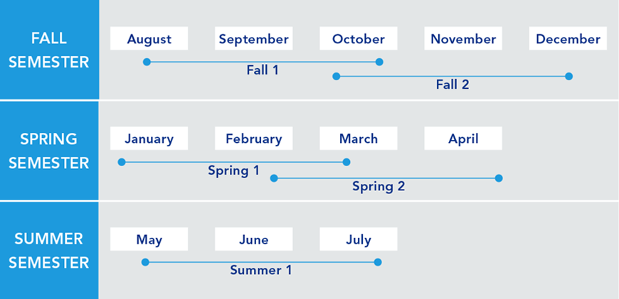
The remote sensing certificate program operates on five 10-week terms. With two terms that partially overlap in fall and spring, and one term in the summer, you are provided with the greatest flexibility possible in completing your degree at your preferred pace.
Registration for most courses begins three months before the start of the course. Given the limited number of seats available in our courses, early registration is strongly encouraged.
Earn Your Certificate in One Year
Whether you are looking to finish your program as quickly as possible or balance your studies with your busy life, Penn State World Campus can help you achieve your education goals. Many students take one or two courses per semester.
A Trusted Leader in Online Education

Penn State has a history of more than 100 years of distance education, and World Campus has been a leader in online learning for more than two decades. Our online learning environment offers the same quality education that our students experience on campus.
Information for Military and Veterans

Are you a member of the military, a veteran, or a military spouse? Please visit our military website for additional information regarding financial aid, transfer credits, and application instructions.
How to Apply to Penn State

How to Apply to Penn State
Apply by August 1 to start August 13
Application Instructions
Deadlines and Important Dates
Complete your application and submit all required materials by the appropriate deadline. Your deadline will depend on the semester you plan to start your courses.
Fall Deadline
Apply by August 1 to start August 13Spring Deadline
Apply by December 15 to start January 7Summer Deadline
Apply by April 15, 2026, to start May 20, 2026
Steps to Apply
To pursue the Graduate Certificate in Remote Sensing and Earth Observation, you must be admitted by two Penn State organizations:
- The J. Jeffrey and Ann Marie Fox Graduate School
- Penn State Department of Geography
For admission to the Fox Graduate School, you must hold either (1) a baccalaureate degree from a regionally accredited U.S. institution or (2) a tertiary (postsecondary) degree that is deemed comparable to a four-year bachelor's degree from a regionally accredited U.S. institution. This degree must be from an officially recognized degree-granting institution in the country in which it operates.
You will need to upload the following items as part of your application:
Official transcripts from each institution attended, regardless of the number of credits or semesters completed. Transcripts not in English must be accompanied by a certified translation. If you are a Penn State alum, you do not need to request transcripts for credits earned at Penn State but must list Penn State as part of your academic history.
English Proficiency — The language of instruction at Penn State is English. With some exceptions, international applicants must take and submit scores for the Test of English as a Foreign Language (TOEFL) or International English Language Testing System (IELTS). Minimum test scores and exceptions are found in the English Proficiency section on the Fox Graduate School's "Requirements for Graduate Admission" page. Visit the TOEFL website for testing information. Penn State's institutional code is 2660.
Test Scores — GRE test scores are NOT required.
To begin the online application, you will need a Penn State account.
Create a New Penn State Account
If you have any problems during this process, contact an admissions counselor at [email protected].
Please note: Former Penn State students may not need to complete the admissions application or create a new Penn State account. Please visit our Returning Students page for instructions.
You can begin your online application at any time. Your progress within the online application system will be saved as you go, allowing you to return at any point as you gather additional information and required materials.
- Choose Enrollment Type: "Certificate Admission"
- Choose "WORLD CAMPUS" as the campus
Checking Your Status
You can check the status of your application by using the same login information established for the online application form.5. Complete the application.
Admissions Help
If you have questions about the admissions process, contact an admissions counselor at [email protected].
Contact Us

Contact Us
Have questions or want more information? We're happy to talk.
Our program specialists are available now to help you with your application and to answer any questions you have about our online geospatial programs. Please contact us with anything you wish to discuss.
Julene Santiago
Geospatial Portfolio Program Assistant
Penn State College of Earth and Mineral Sciences
[email protected]
Phone: 814-865-2557
To see more detailed information about the geospatial portfolio, visit the program website within Penn State's College of Earth and Mineral Sciences. You can also visit Penn State’s Repository of Open and Affordable Materials (ROAM) to preview some of the geospatial courses offered online by the Department of Geography.
For general questions about Penn State World Campus, please contact:
World Campus Admissions Counselors
Phone: 814-863-5386
[email protected]
Learn from the Best
Learn from the Best
The Graduate Certificate in Remote Sensing and Earth Observation is offered in partnership with the Penn State College of Earth and Mineral Sciences. Our courses are taught by distinguished faculty who have special training and experience teaching in an online environment.
Faculty
Brandi Gaertner
DegreePh.D., Forestry and Natural Resources, West Virginia UniversityDr. Brandi Gaertner, assistant teaching professor of spatial data science in the online geospatial education program, joined the Penn State faculty in 2021. Dr. Gaertner is a climate change hydrologist and GIS analyst. Her research focus is on evaluating historical and future impacts of climate change on surface streamflow and climate variables such as precipitation and temperature.
Karen Schuckman
- DegreeM.S., Geographic Information Systems, Penn State
- DegreeB.A., Liberal Arts, Penn State
- DegreeB.S., Meteorology, Penn State
Karen Schuckman's teaching and research interests include applications of airborne and spaceborne remote sensing to topographic mapping, land-use/land-cover analysis, positional accuracy assessment of remotely sensed base map data products, and other geospatial applications.
Anthony C. Robinson, Ph.D.
- DegreePh.D., Geography, Penn State
- DegreeM.S., Geography, Penn State
- DegreeB.S., Applied Geography, East Carolina University
Dr. Anthony C. Robinson, professor of geography, serves as the director of online geospatial education at Penn State. He is also the faculty director for the GeoGraphics Lab in the Department of Geography and former president of the North American Cartographic Information Society (NACIS). Dr. Robinson is a cartographer who designs and evaluates geovisualization tools to improve geographic information utility and usability. He has worked in epidemiology, crisis management, national security, and education domains to develop and evaluate new methods for visualizing spatial data.
News


