100% Online
Complete your Penn State course work at your own pace and 100% online.
Application deadline
Credits and costs
10-Week Terms
Finish your program faster with accelerated 10-week terms.
Gain Skills to Work at the Forefront of the Industry with a GIS Degree
Design and leverage geographic information systems and spatial analysis tools to tackle real-world problems that impact people and our planet.
Apply analytical methods for geospatial data, including pattern analysis, interpolation, cluster detection, surface analysis, overlay analysis, and measures of spatial autocorrelation.
Use expertise in spatial data integration as well as geospatial database design, creation, and maintenance.
Facilitate spatial data analysis and use maps and visualizations to communicate findings to stakeholders.
Gain core competencies to help prepare for the GIS Professional (GISP) certification.
Online GIS Master’s Program Courses and Tracks
Online GIS Master’s Program Courses and Tracks
This 33-credit graduate program delivers the depth of knowledge and hands-on expertise you need to become a leader in your industry. Convenient online courses are designed to teach you cutting-edge advances in GIS tools and spatial analysis methods.
As a geospatial professional, you can also take our courses to fulfill continuing professional development requirements by enrolling as a nondegree student.
We continually update our curriculum by integrating contemporary geospatial technologies and emerging topics, including:
- open web mapping
- spatial data science
- location intelligence for business
- GIS for conservation or environmental studies
- remote sensing
- advanced Python programming
- and more
The curriculum, including challenging projects, teaches crucial skills that you can apply to your professional work.
Course requirements include a minimum of 18 credits at the 500 or 800 level, with at least 6 credits at the 500 level, and a supervised independent capstone project. Courses within the Geospatial Intelligence Option and the Geodesign Option may be taken as elective courses.
You can complete this respected graduate program part-time and online in as little as two and a half years.
Specialized Tracks Available
Specialized tracks allow you to develop focused expertise without extending the length of your graduate degree program. Customize your program in either geospatial intelligence or geodesign.
Geospatial Intelligence (GEOINT)
Produce information and insights through skillful and conscientious analysis of diverse geo-referenced data to manage natural and cultural assets, plan for emergencies, coordinate responses to natural and human-induced disasters, enforce the law, and plan and conduct military operations.
Geodesign
Combine science and evidence-based approaches with the design process, enabling you to become more adept at assessing the impact of designs on people and nature. This option is designed for current or aspiring professionals who seek a foundation in geospatially based design through investigating the methods and collaborative nature of the geodesign process.
You may also apply to the base MGIS program and design a curriculum that better aligns with your unique career goals.
Students earn the MGIS degree by successfully completing 33 credits of course work, including a supervised independent capstone project. Course requirements include a minimum of 18 credits at the 500 or 800 level, with at least 6 credits at the 500 level. Courses within the Geospatial Intelligence Option and the Geodesign Option may be taken as elective courses.
MGIS Base Program (33 credits)
This pathway offers a wider range of elective credits, providing you with the highest degree of customization.
Required Courses (18 credits)
- 3credits
Case studies, student investigations, and projects reveal the scope, impact, and character of the Geospatial Revolution.
- or:3credits
Traces the roots of spatial data science ethics in moral philosophy, professional ethics frameworks, and critical studies. Students will critique legal and policy issues in the U.S. and abroad.
- 3credits
How geographic information systems facilitate data analysis and communication to address common geographic problems.
- Prerequisite
GEOG 482 or permission of the program
- 3credits
Database design, creation, maintenance, and data integration using desktop GIS software.
- Prerequisite
GEOG 483 or permission of the program
- 3credits
Systematic approach to requirements acquisition, specification, design, and implementation of geospatial information systems.
- Prerequisite
GEOG 484
- 3credits
Choosing and applying analytical methods for geospatial data, including point pattern analysis, interpolation, surface analysis, overlay analysis, and spatial autocorrelation.
- Prerequisite
GEOG 485 or GEOG 486 or GEOG 487
- 3credits
Principles of effective project management applied to the design and implementation of geospatial information systems.
Culminating Experience (3 credits)
- 3credits
Develop an applied spatial analysis project that utilizes contemporary methods, technologies, and data sources to solve a problem in the student's field.
Electives (12 credits)
MGIS with Geospatial Intelligence Option (33 credits)
The geospatial intelligence (GEOINT) option is designed for current or aspiring practitioners that rely on insights produced through skillful, knowledgeable, and conscientious analysis of diverse geo-referenced data to plan for emergencies, coordinate responses to natural and human-induced disasters, enforce the law, and plan and conduct military operations.
Required Courses (9 credits)
- 3credits
Systematic approach to requirements acquisition, specification, design, and implementation of geospatial information systems.
- Prerequisite
GEOG 484
- 3credits
Choosing and applying analytical methods for geospatial data, including point pattern analysis, interpolation, surface analysis, overlay analysis, and spatial autocorrelation.
- Prerequisite
GEOG 485 or GEOG 486 or GEOG 487
- 3credits
Principles of effective project management applied to the design and implementation of geospatial information systems.
- Prerequisite
GEOG 583
GEOINT Option Courses (15 credits)
- 3credits
The application of cultural geography in the intelligence analysis and synthesis process by identifying prominent threats to civil security.
- 3credits
Orientation to the geographic foundations of geospatial intelligence and its applications in national security, international relief work, and disaster management.
- 3credits
Understanding remote sensing systems' operation, data products, and processing techniques to address typical problem scenarios faced by the GEOINT professional.
- 3credits
The course highlights the tradecraft of integrating spatial data science with geospatial intelligence methods; students practice this integration by preparing intelligence reports requiring GIS tools.
- 3credits
Focuses on the science and technology of human-machine collaboration using geospatial artificial intelligence (GeoAI) in GEOINT and the professional and ethical concerns that must be considered in this rapidly evolving field.
- Prerequisite
GEOG 882
Culminating Experience (3 credits)
- 3credits
Develop an applied spatial analysis project that utilizes contemporary methods, technologies, and data sources to solve a problem in the student's field.
Electives (select 6 credits)
MGIS with Geodesign Option (33 credits)
This option is designed for current or aspiring professionals who seek a foundation in geospatially based design through investigating the methods and collaborative nature of the geodesign process.
Required Courses (15 credits)
- 3credits
Case studies, student investigations, and projects reveal the scope, impact, and character of the Geospatial Revolution.
- or:3credits
Traces the roots of spatial data science ethics in moral philosophy, professional ethics frameworks, and critical studies. Students will critique legal and policy issues in the U.S. and abroad.
- 3credits
How geographic information systems facilitate data analysis and communication to address common geographic problems.
- Prerequisite
GEOG 482
- 3credits
Systematic approach to requirements acquisition, specification, design, and implementation of geospatial information systems.
- Prerequisite
GEOG 484
- 3credits
Choosing and applying analytical methods for geospatial data, including point pattern analysis, interpolation, surface analysis, overlay analysis, and spatial autocorrelation.
- Prerequisite
GEOG 485 or GEOG 486 or GEOG 487
- 3credits
Principles of effective project management applied to the design and implementation of geospatial information systems.
- Prerequisite
GEOG 583
Geodesign Option Courses (12 credits)
- 3credits
Students study the theory and principles of geospatially based design by investigating the methods and collaborative nature of the geodesign process.
- Prerequisite
GEOG 482 (Please contact the program to discuss waiving this requirement.)
- 3credits
The principles, inherent values, and practical applications of evaluation and decision models as implemented within the geodesign framework.
- Prerequisite
GEODZ 511
- 3credits
Real-world applications of GIS and spatial analysis to investigate a variety of current environmental issues.
- 3credits
Theory and practical applications of using cloud computing and server resources to solve geospatial problems. Technologies: ArcGIS Server, Portal for ArcGIS, ArcGIS Online, GeoServer, CARTO, Amazon Web Services, Mapbox, Google Fusion Tables Theory.
- Prerequisite
GEOG 484 or permission of the program
Culminating Experience (3 credits)
- 3credits
Develop an applied spatial analysis project that utilizes contemporary methods, technologies, and data sources to solve a problem in the student's field.
Electives (3 credits)
Elective Courses List
Tailor your master’s program with electives that further align with your personal strengths, professional interests, or career goals. Elective courses may change over time to better meet the industry needs and student demands. Contact the academic home at [email protected] for an updated list.
Elective courses may not be double counted to meet the requirement for any prescribed or option-related courses.
Current courses may include:
- 3credits
Examines the nexus of geospatial intelligence analysis with cyberspace, the geopolitics of cyber threats, the politics of censorship and hacking, public safety, disaster response, and humanitarian relief; students will utilize a range of cyber data, systems, and spatial sciences to examine human social networks of the internet.
- Prerequisite
GEOG 160 or GEOG 482 or permission of program
- 3credits
Using imagery and terrain data in typical application scenarios faced by the geospatial professional.
- 3credits
Understanding lidar systems; design, operation, data processing techniques, and product generation to address typical application scenarios faced by the geospatial professional.
- 3credits
Customizing GIS software to extend its built-in functionality and to automate repetitive tasks.
- Prerequisite
GEOG 484 or permission of the program
- 3credits
Theory and practice of cartographic design, emphasizing effective visual thinking and visual communication with geographic information systems. Technologies: ArcGIS Pro, Mapbox Studio, QGIS
- Prerequisite
GEOG 484 or permission of the program
- 3credits
Learn advanced applications of Python for developing and customizing GIS software, designing user interfaces, and solving complex geoprocessing tasks using both proprietary and open source platforms. Technologies: ArcGIS Pro, ArcPy, Jupyter Notebooks, ArcGIS API for Python, QGIS, GDAL/OGR.
- Prerequisite
GEOG 485 or permission of the program
- 3credits
The application of cultural geography in the intelligence analysis and synthesis process by identifying prominent threats to civil security.
- 3credits
Traces the roots of spatial data science ethics in moral philosophy, professional ethics frameworks, and critical studies. Students will critique legal and policy issues in the U.S. and abroad.
- 3credits
Design, development, and implementation of web mapping applications using OGC standards and open source software. Technologies: JavaScript, QGIS, GDAL, OGR, GeoServer, TileMill, Leaflet, and OpenStreetMap
- Prerequisite
GEOG 485
- 3credits
Focuses on theoretical discussions on relevant topics and methods used in spatial data science, as well as on applying a range of spatial data science skills and tools to solve real-world problems and model geographic phenomena.
- 3credits
Advanced topics in remote sensing and image processing, including new sensors, applications, and decision-making.
- 3credits
The role of geographic information systems in understanding disease, including relevant spatial analysis and cartographic visualization techniques.
- Prerequisite
GEOG 484 or permission of the program
- 3credits
Understanding location technology and geospatial analysis to support an efficient and effective pathway to better business decisions.
- 3credits
Requirements analysis and proposal writing to plan and implement GIS solutions supporting emergency management activities of government agencies and contractors.
- Recommended Preparation
GEOG 483
- 3credits
Explores three important topics related to georeferenced data: datums, map projections, and grid systems.
- Prerequisite
GEOG 483 or permission of the program
- 3credits
Focuses on how geospatial professionals can create applications using industry-related geospatial APIs. Students will build applications using the core web technologies of HTML, CSS, and JavaScript. Technologies: JavaScript, ArcGIS API for JavaScript, ArcGIS Online, CSS
- 3credits
Advanced topics in the storage, management, and retrieval of geospatial data using common proprietary and open-source relational database technologies. Technologies: SQL, PostGIS, ArcSDE/Multiuser Geodatabases, QGISAdvanced.
- 3credits
Common platforms, analytical strategies, and policy dimensions of Unmanned Aerial Systems (UAS) in public, private, defense, and humanitarian applications.
- 3credits
Analysis of multivariate data; T2-tests; particle correlation; discrimination; MANOVA; cluster analysis; regression; growth curves; factor analysis; principal components; canonical correlations.
- Prerequisite
STAT 500 and STAT 501; matrix algebra
About the Capstone Project
The capstone course (GEOG 870) develops Master of Geographic Information Systems students' research and technical competencies to meet degree requirements and serve their future career goals. Students completing this course will synthesize the learning they have completed in their MGIS course work and develop an applied spatial analysis project that utilizes contemporary methods, technologies, and data sources to solve a problem in their field. The course makes use of discussions, presentations, directed independent research, collaborative critiques, and an individual scholarly paper.
Course Availability
If you're ready to see when your courses will be offered, visit our public LionPATH course search (opens in new window) to start planning ahead.
Advance Your GIS Career

Advance Your GIS Career
You can use the knowledge gained from this online geospatial program and the support of Penn State career resources to pursue careers in a variety of fields, depending on your goals.
Job Titles Related to This Degree
The following roles are often held by people with this type of degree:
- Digital Cartographer
- GIS Consultant
- GIS/Geospatial Analyst
- LIDAR Analyst
- Photogrammetrist
- Remote Sensing Specialist
Employment Outlook for Occupational Fields Related to This Degree
Estimates of employment growth and total employment are provided by the U.S. Bureau of Labor Statistics and are subject to change. While these occupations are often pursued by graduates with this degree, individual outcomes may vary depending on a variety of factors. Penn State World Campus cannot guarantee employment in a given occupation.
Surveying and Mapping Technicians
Cartographers and Photogrammetrists
Physical Scientists, All Other
Geographers
Career Services to Set You Up for Success

From the day you're accepted as a student, you can access resources and tools provided by Penn State World Campus Career Services to further your career. These resources are beneficial whether you're searching for a job or advancing in an established career.
- Opportunities to connect with employers
- Career counselor/coach support
- Occupation and salary information
- Internships
- Graduate school resources
Additional Fields and Opportunities
By advancing your education online, you’ll be well on your way to designing, specifying, and managing complex geographic information infrastructures as a leader in a variety of fields such as:
- environmental resource management
- transportation and urban planning
- government services
- surveying and cartography
- emergency preparedness and response
- GIS software development and geospatial technology
- climate science
- data visualization and web mapping
- geospatial intelligence
Ready to Learn More?
Get the resources you need to make informed decisions about your education. Request information on this program and other programs of interest by completing this form.
Ready to take the next step toward your Penn State master's degree?
Costs and Financial Aid
Costs and Financial Aid
Learn about this program's tuition, fees, scholarship opportunities, grants, payment options, and military benefits.
Costs and Financial Aid
Graduate Tuition
Graduate tuition is calculated based on the number of credits for which you register. Tuition is due shortly after each semester begins and rates are assessed every semester of enrollment.
2025–26 Academic Year Rates
| How many credits do you plan to take per semester? | Cost |
|---|---|
| 11 or fewer | $1,037 per credit |
| 12 or more | $12,448 per semester |
2026–27 Academic Year Rates
| How many credits do you plan to take per semester? | Cost |
|---|---|
| 11 or fewer | $1,048 per credit |
| 12 or more | $12,572 per semester |
Financial Aid and Military Benefits
Some students may qualify for financial aid. Take the time to research financial aid, scholarships, and payment options as you prepare to apply. Federal financial aid may only be used to pay for credits used to satisfy program requirements.
Military service members, veterans, and their spouses or dependents should explore these potential military education benefits and financial aid opportunities, as well.
Additional Cost of Attendance Details
To view the detailed list of cost of attendance elements:
- visit the Tuition Information site
- click the plus sign to expand the table
- select a semester from the World Campus row
Technical Requirements
Review the technical requirements for this program.
Earn a Valuable Credential along the Way

Earn a Valuable Credential along the Way
Show mastery of specific subjects before your degree is complete. Thanks to shared courses across programs, students can often earn a certificate along with their degree in less time than if they earned them separately.
Certificate Programs Related to This Degree
The following certificates can be earned while completing this degree program:
This online GIS certificate program provides students with hands-on course experiences to develop technical skills using the latest mapping tools in the geospatial industry. Kickstart or advance your career as a GIS analyst or applications specialist. Learn how you can apply credits toward a master’s degree.
Learn more about the Postbaccalaureate Certificate in Geographic Information SystemsThis online GEOINT certificate can help jumpstart or advance your career as a geospatial intelligence or imagery analyst. Apply geospatial information science and technology (GIST), knowledge of spatial relationships, and cognitive processes to improve problem-solving and decision-making.
Learn more about the Graduate Certificate in Geospatial Intelligence AnalyticsThis online programming certificate can expand your web mapping and coding skills. Geospatial professionals can learn to create web-based interactive mapping applications that support spatial data science. Prior programming experience is not required.
Learn more about the Graduate Certificate in Geospatial Programming and Web Map DevelopmentLearn to leverage data gathered from drones, satellites, and lidar. This certificate focuses on remote sensing, terrain mapping, and image analysis and draws upon the resources of one of the most respected online GIS programs in the U.S.
Learn more about the Graduate Certificate in Remote Sensing and Earth ObservationCertification/Partnerships
This program can help you prepare for the GIS Professional (GISP) certification offered by the GIS Certification Institute. In addition, courses in our program can help you acquire the points you need to obtain recertification if you already have GISP certification.
Act 48–Compliant
The GIS courses meet Pennsylvania Act 48 requirements for continuing teacher education, which parallel similar education requirements of other states.
Progressive Curriculum
The GIS curriculum is set up to ensure you first learn key skills and competencies before advancing to more complex topics.
The first-year courses are designed to help you develop the information literacy and technical competencies you need to become a more knowledgeable and skillful GIS user. Upon successfully completing the first year, you will receive a Postbaccalaureate Certificate in GIS*, provided that you also apply to that program.
For experienced GIS professionals, we work with you to develop a customized curriculum that fits your goals and ensures you do not have to repeat classes in areas where you are already proficient. This curriculum allows you to earn a respected certificate while you continue to work toward your master's degree.
*A separate application and program acceptance are required for each credential. Please email the program office at [email protected] for more details.
The second-year courses can prepare you to design, specify, and manage complex geographic information infrastructures for your organization. Depending upon your course selection, you may have the opportunity to earn a second GIS–related graduate certificate.*
*A separate application and program acceptance are required for each credential. Please email the program office at [email protected] for more details.
During the third year, you will complete any remaining electives and an independent study capstone project, through which you will make a substantive contribution to your organization.
Depending on course availability, you can complete the MGIS degree in as little as two and a half years or spread out the courses to suit your personal responsibilities and work commitments. We make it easy to pause and restart your studies at any time.
Take Advantage of Flexible Course Scheduling
Take Advantage of Flexible Course Scheduling
The MGIS program operates on five 10-week terms. With two terms that partially overlap in fall and spring, and one term in the summer, you are provided with the greatest flexibility possible in completing your degree at your preferred pace.
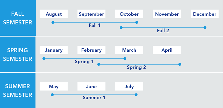
Finish Your GIS Master's Degree in About Two Years
Whether you are looking to finish your program as quickly as possible or balance your studies with your busy life, Penn State World Campus can help you achieve your education goals. Students in our graduate geospatial programs typically take one course per 10-week term.
Convenient Online Format
This program's convenient online format gives you the flexibility you need to study around your busy schedule. You can skip the lengthy commute without sacrificing the quality of your education and prepare yourself for more rewarding career opportunities without leaving your home.
A Trusted Leader in Online Education

Penn State has a history of more than 100 years of distance education, and World Campus has been a leader in online learning for more than two decades. Our online learning environment offers the same quality education that our students experience on campus.
How to Apply to Penn State

How to Apply to Penn State
Apply by November 1 to start January 12
Application Instructions
Deadlines and Important Dates
Complete your application and submit all required materials by the appropriate deadline. Your deadline will depend on the semester you plan to start your courses.
Spring Deadline
Apply by November 1 to start January 12Summer Deadline
Apply by April 1, 2026, to start May 18, 2026Fall Deadline
Apply by July 1, 2026, to start August 24, 2026
Steps to Apply
For admission to the J. Jeffrey and Ann Marie Fox Graduate School, an applicant must hold either (1) a baccalaureate degree from a regionally accredited U.S. institution or (2) a tertiary (postsecondary) degree that is deemed comparable to a four-year bachelor's degree from a regionally accredited U.S. institution. This degree must be from an officially recognized degree-granting institution in the country in which it operates.
Accelerated Admission Option
Applying to the award-winning Penn State MGIS program has never been easier. If you begin in one of our GIS, GEOINT, spatial data science, geospatial programming, or remote sensing certificate programs and earn a 3.67 GPA or higher after completing the first three courses, you may be eligible for accelerated admission.
Advantages of the accelerated admission option include:
- no professional experience is required
- no letters of recommendation are required
Admissions decisions will be made in this manner on a rolling basis year-round, but you must have your application complete and submitted for consideration at least 4 weeks before the term in which you intend to start the degree program. Please contact the academic home directly at [email protected] with any questions.
Applications are submitted electronically and include a nonrefundable application fee. You will need to upload the following items as part of your application:
Official transcripts from each institution attended, regardless of the number of credits or semesters completed. Transcripts not in English must be accompanied by a certified translation. If you are a Penn State alum, you do not need to request transcripts for credits earned at Penn State but must list Penn State as part of your academic history.
Test scores — GRE scores are NOT required.
English Proficiency — The language of instruction at Penn State is English. With some exceptions, international applicants must take and submit scores for the Test of English as a Foreign Language (TOEFL) or International English Language Testing System (IELTS). Minimum test scores and exceptions are found in the English Proficiency section on the Fox Graduate School's "Requirements for Graduate Admission" page. Visit the TOEFL website for testing information. Penn State's institutional code is 2660.
References — Regular Admission Option: Two letters of reference are required. You will need to initiate the process through the online application by entering names, email addresses, and mailing addresses of three references. Upon submission of your application, an email will be sent to each reference requesting they complete a brief online recommendation regarding your commitment for success in an online program.
Accelerated Admission Option: No external references are required.
Program-Specific Questions/Materials
Résumé — A one- to five-page listing of your professional experience and education.
Personal Statement — Accelerated & Regular Admission Options: Write a statement (2–3 pages in length) describing how your experience and goals align with the Master of GIS program.
To begin the online application, you will need a Penn State account.
Create a New Penn State Account
If you have any problems during this process, contact an admissions counselor at [email protected].
Please note: Former Penn State students may not need to complete the admissions application or create a new Penn State account. Please visit our Returning Students page for instructions.
You can begin your online application at any time. Your progress within the online application system will be saved as you go, allowing you to return at any point as you gather additional information and required materials.
- Choose Enrollment Type: "Degree Admission"
- Choose "WORLD CAMPUS" as the campus
Checking Your Status
You can check the status of your application by using the same login information established for the online application form.5. Complete the application.
Admissions Help
If you have questions about the admissions process, contact an admissions counselor at [email protected].
Contact Us

Contact Us
Have questions or want more information? We're happy to talk.
Our program specialists are available now to help you with your application and to answer any questions you have about our online geospatial programs. Please contact us with anything you wish to discuss.
Julene Santiago
Geospatial Portfolio Program Assistant
Penn State College of Earth and Mineral Sciences
[email protected]
Phone: 814-865-2557
To see more detailed information about the geospatial portfolio, visit the program website within Penn State's College of Earth and Mineral Sciences. You can also visit Penn State’s Repository of Open and Affordable Materials (ROAM) to preview some of the geospatial courses offered online by the Department of Geography.
For general questions about Penn State World Campus, please contact:
World Campus Admissions Counselors
Phone: 814-863-5386
[email protected]
Learn from the Best
Learn from the Best
Penn State's GIS program is offered in partnership with the Department of Geography within Penn State's College of Earth and Mineral Sciences. It has been a trusted leader in online education since 1998, so you can take pride in knowing you are part of a recognized, award-winning program.
Faculty
Anthony C. Robinson, Ph.D.
- DegreePh.D., Geography, Penn State
- DegreeM.S., Geography, Penn State
- DegreeB.S., Applied Geography, East Carolina University
Dr. Anthony C. Robinson, professor of geography, serves as the director of online geospatial education at Penn State. He is also the faculty director for the GeoGraphics Lab in the Department of Geography and former president of the North American Cartographic Information Society (NACIS). Dr. Robinson is a cartographer who designs and evaluates geovisualization tools to improve geographic information utility and usability. He has worked in epidemiology, crisis management, national security, and education domains to develop and evaluate new methods for visualizing spatial data.
Ryan Baxter
- DegreeM.S., Geography, Penn State
- DegreeB.A., Geography and Environmental Sciences, Northwestern University
Ryan Baxter advises students and teaches courses in topics including renewable energy, environmental applications of GIS, cloud and server GIS technologies, and introductory geographic information concepts. He is active in technical research projects involving spatial databases, online data discovery tools, interactive mapping applications, and cloud-based GIS services. He is also engaged in research investigating the spatial modeling of land use change, quantifying the amount of land available for bioenergy feedstocks, and assessing the suitability and productivity of energy crops.
Amy Burnicki
DegreePh.D., Natural Resources & Environment, University of MichiganDr. Amy Burnicki is an associate teaching professor in the Department of Geography. Her research applies spatial data analysis, spatial statistics, and quantitative modeling approaches in the field of land change science and in transportation and environmental engineering applications.
James Detwiler
- DegreeM.S., Geography, University of Delaware
- DegreeB.S., Earth Science, Penn State
James Detwiler is in a 100% teaching appointment and specializes in GIS programming. He teaches GEOG 485: GIS Programming and Automation; GEOG 863: Web Application Development; and GEOG 868: Spatial Database Management. His research interests are in the areas of applied GIS and climatology.
Brandi Gaertner
DegreePh.D., Forestry and Natural Resources, West Virginia UniversityDr. Brandi Gaertner, assistant teaching professor of spatial data science in the online geospatial education program, joined the Penn State faculty in 2021. Dr. Gaertner is a climate change hydrologist and GIS analyst. Her research focus is on evaluating historical and future impacts of climate change on surface streamflow and climate variables such as precipitation and temperature.
Adrienne Goldsberry
- DegreeM.A., Geography, University of California - Santa Barbara
- DegreeB.A., Geography, The University of Texas at Austin
Adrienne Goldsberry is an instructor as well as adviser for students in the Postbaccalaureate Certificate in Geographic Information Systems program. Before joining Penn State, she was an online instructor for Michigan State University's Department of Geography, Environment, and Spatial Sciences and managed its online Professional Certificate in GIS. She also worked as an urban planner for jurisdictions in California, Texas, and Michigan.
Panagiotis Giannakis
- DegreePh.D., Geosciences, University of Arkansas
- DegreeM.S., Human Resource Management, Athens University of Economics & Business
Panagiotis Giannakis is an Assistant Teaching Professor in the Department of Geography and the Dutton e-Education Institute within the College of Earth & Mineral Sciences. He received his PhD from the University of Arkansas, where he also maintained a key role in the advancement of the Online Geospatial Certificate program. His research interests lie at the intersection of Economic Geography, Strategic Management, and Social Networks. More specifically, Panagiotis’ research focuses on the relationship between organizational and physical and/or social network space.
Fritz Kessler
- DegreePh.D., Geography, University of Kansas
- DegreeM.S., Geography, Penn State
- DegreeB.S., Geography, Ohio University
Dr. Fritz Kessler's teaching interests include cartography, geographic visualization, map projections, spatial analysis, land surveying, geography of health, and statistics. His research interests include map projections, geographic visualization, history of cartography, and cognitive cartography.
Beth King
- DegreeM.Ed., Adult Education, Penn State
- DegreeB.S., Geography, Penn State
Beth King is co-author and instructor of GEOG 483: Problem-Solving with GIS; GEOG 482: Making Maps that Matter with GIS; and GEOG 597G: Challenges in Global Geospatial Analytics. She is assistant program manager for Online Geospatial Education and maintains regular communication with students in the MGIS degree program to identify their questions and concerns. Previously, she worked as a GIS analyst for a private water/wastewater engineering firm, where she managed a wide range of GIS projects, from turnkey sanitary sewer conversion to 911 rural addressing.
Karen Schuckman
- DegreeM.S., Geographic Information Systems, Penn State
- DegreeB.A., Liberal Arts, Penn State
- DegreeB.S., Meteorology, Penn State
Karen Schuckman's teaching and research interests include applications of airborne and spaceborne remote sensing to topographic mapping, land-use/land-cover analysis, positional accuracy assessment of remotely sensed base map data products, and other geospatial applications.
Marcela Suárez
DegreePh.D., Geography, University of California, Santa BarbaraDr. Marcela Suárez is an assistant teaching professor in the Department of Geography and the John A. Dutton Institute for Teaching and Learning Excellence within the College of Earth and Mineral Sciences. Dr. Suárez 's research interests lie at the intersection of geographic information science, cartography, and emergency management.
Gregory Thomas
- DegreePh.D., Administration and Leadership Studies, Indiana University of Pennsylvania
- DegreeMPA, Penn State
- DegreeB.S., Criminal Justice, Shippensburg University of Pennsylvania
Dr. Gregory Thomas has experience developing intelligence for decision-makers, supervising the analytical process, and providing team guidance. He also has experience teaching intelligence and analytical techniques to college students as well as intelligence analysts and law enforcement personnel. He has developed operational intelligence to support criminal investigations and anti-terrorism activities, and has selected, trained, and supervised analysts in a criminal intelligence center. His teaching and research focus on geospatial intelligence analysis, homeland security, and criminal intelligence.
Michelle Zeiders
- DegreeM.S., Geoenvironmental Studies, Shippensburg University of Pennsylvania
- DegreeB.S., Public Administration, Shippensburg University of Pennsylvania
Michelle Zeiders teaches GEOG 483: Problem-Solving with GIS; GEOG 484: GIS Database Development; and GEOG 487: Environmental Applications of GIS. She has been teaching introductory and software-intensive GIS courses since 1998. Prior to joining the geospatial education program, she worked as a GIS programmer/instructor for the Penn State Population Research Institute, a GIS project manager/instructor for the Institute for Transportation Research and Education at North Carolina State University, a GIS project manager at a private civil engineering firm, and a GIS analyst at MapQuest.
News